Quinnipiac River
| Quinnipiac River Dragon River, East River, New Haven River[1] | |
|---|---|
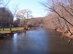
 The Quinnipiac River, as seen looking west (upstream) from "Red Bridge" in Meriden, Connecticut | |
 | |
| Location | |
| Country | United States |
| State | Connecticut |
| Region | New Haven, Hartford |
| District | North Haven, Wallingford, Cheshire, Southington, Plainville |
| Cities | New Haven, Meriden |
| Physical characteristics | |
| Source | Deadwood Swamp |
| • location | Farmington, Connecticut, Hartford County, Connecticut, United States |
| • coordinates | 41°41′42″N 072°48′55″W / 41.69500°N 72.81528°W[3] |
| • elevation | 335 ft (102 m) |
| Mouth | New Haven Harbor, New Haven, Connecticut |
• location | Long Island Sound, New Haven County, Connecticut, United States |
• coordinates | 41°17′58″N 072°54′14″W / 41.29944°N 72.90389°W[3] |
• elevation | 0 ft (0 m) |
| Length | 45.5 mi (73.2 km) |
| Discharge | |
| • location | mouth |
| • average | 414 cu ft/s (11.7 m3/s) (estimate)[2] |
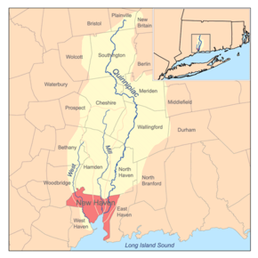
The Quinnipiac River (/ˈkwɪnəˌpi.æk/ KWIH-nə-pee-ak) is a 45.5-mile (73.2 km)[4] long river in the New England region of the United States, located entirely in the state of Connecticut.
The river rises in West Central Connecticut from Dead Wood Swamp near the city of New Britain. It flows roughly southward to Plainville, Southington, and Cheshire, west of the city of Meriden, through Wallingford and Yalesville, North Haven, and flows into New Haven Harbor, an inlet of Long Island Sound, east of downtown New Haven.
History
[edit]

The name "Quinnipiac" comes from an Algonquian phrase meaning "long water land", and historically referred both to the river and the area around its mouth at Long Island Sound. Europeans found the river in 1614. By the early 18th century, early settlers called the Quinnipiac River the Dragon River after the seals, then referred to as “sea dragons,” that were once abundant there.[5] Although these seals were likely harbor seals (Phoca vitulina), archaeological evidence confirms that gray seals (Halichoerus grypus), which are over twice the size of a harbor seal, also lived near the mouth of the Quinnipiac River as recently as the sixteenth century.[6]
Watershed and course
[edit]The Quinnipiac River watershed drains an area of approximately 165 square miles (430 km2).[7] There are four dams, most of which are old remnants, that impede boat travel. The first dam is about 1/2 mile south of Plantsville, the second dam is at the southeast corner of Hanover Pond in South Meriden, the third dam is in northeast Yalesville, and the fourth dam is at the south end of Community Lake in Wallingford.
In April 2017, a small hydroelectric plant using a screw turbine was installed at Hanover Pond.[8]
Paddling is a frequent recreational activity along the Quinnipiac River, especially within the tidal marsh in North Haven. Additionally, the tidal variation extends approximately 14 miles (23 km) upriver from its mouth.
Ecology and conservation
[edit]Throughout the 19th and 20th centuries, the river suffered from severe pollution problems because of the presence of heavy industry and population centers in its watershed. The Quinnipiac was the subject of the first ever pollution control measure in the state of Connecticut. In 1886, the state legislature passed a measure prohibiting the City of Meriden from discharging raw sewage into the river. In 1891, the act resulted in the building of state's second sewage treatment plant.[5]
Nevertheless, by 1914, the State Board of Health reported that the major fish life had largely disappeared from its mouth. The pollution has been somewhat abated by the passage of the Connecticut Clean Water Act of 1967, and by the Water Pollution Control Act of 1972, which provided the legal authority to take measures to clean up the river's watershed. The measures included the construction of advanced waste management facilities for sewage and industrial waste. Levels of copper in the river have decreased 70% since the 1980s and are now comparable to other reference streams in Connecticut. Combined sewer overflows from the City of New Haven are still regarded as a major problem for the estuary.
Recreation
[edit]Paralleling the west bank of the Quinnipiac River through the entire length of Quinnipiac River State Park in North Haven is the Quinnipiac Trail.
Crossings
[edit]| County | Town | Carrying |
|---|---|---|
| Hartford | Plainville | |
| Crooked Street (SSR 536) | ||
| Woodford Avenue (SSR 536) | ||
| Tomlinson Avenue | ||
| Stillwell Drive | ||
| Shuttlemeadow Road | ||
| Southington | Route 10 | |
| Newell Street | ||
| West Queen Street | ||
| Spring Street | ||
| Lazy Lane | ||
| Curtiss Street | ||
| Hart Street | ||
| Mill Street | ||
| Center Street | ||
| West Center Street | ||
| West Main Street | ||
| Atwater Street | ||
| Route 10 | ||
| Old Turnpike Road. | ||
| New Haven | Cheshire | |
| East Johnson Avenue | ||
| Blacks Road | ||
| Cheshire Street | ||
| Meriden | Oregon Road | |
| Main Street | ||
| Wallingford | Oak Street | |
| Quinnipiac Street | ||
| Toelles Road | ||
| North Haven | ||
| Broadway | ||
| Sackett Point Road | ||
| New Haven | Middletown Avenue | |
| Grand Avenue | ||
| Ferry Street | ||
See also
[edit]References
[edit]- ^ Hughes, Arthur; Morse S. Allen (1976). Connecticut Place Names. Hartford, Connecticut: The Connecticut Historical Society. p. 364.
- ^ United States Environmental Protection Agency. "Watershed Report: Quinnipiac River". WATERS GeoViewer. Archived from the original on 2021-09-13. Retrieved 2021-09-13.
- ^ a b "Quinnipiac River". Geographic Names Information System. United States Geological Survey, United States Department of the Interior.
- ^ U.S. Geological Survey. National Hydrography Dataset high-resolution flowline data. The National Map Archived 2012-03-29 at the Wayback Machine, accessed April 1, 2011
- ^ a b "The Quinnipiac River". Quinnipiac River Fund. Retrieved 2015-02-08.
- ^ Joseph H. Waters (February 1967). "Gray Seal Remains from Southern New England Archeological Sites". Journal of Mammalogy. 48 (1): 139–141. doi:10.2307/1378182. JSTOR 137818.
- ^ State of Connecticut Department of Environmental Protection, A Total Maximum Daily Load Analysis for the Quinnipiac River Regional Basin Archived May 28, 2010, at the Wayback Machine, June 4, 2008
- ^ Andrew Ragall, Ancient technology in Meriden's Hanover Pond dam begins generating electricity, Meriden Record Journal, Apr. 27, 2017.
External links
[edit]- Quinnipiac River Fund home page
- Connecticut Department of Environment Protection: Quinnipiac River
- Quinnipiac River Historic District, New Haven.
- Quinnipiac River Watershed Association, located on Hanover Pond, Oregon Road, City of Meriden, CT.
- Connecticut Explorer's Guide Online paddling map of the Quinnipiac River
